
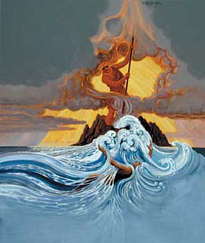
Goddess Pele, creates land and destroys whatever impedes the process, whether vacant forest or inhabited towns. The land is hers, and she does with it as she likes, when she likes. The goddess can be beautiful and loving as shown here in Arthur Johnson’s depiction of Pele carrying her embryonic sister Hia`aka in an egg. She can also be fierce, vengeful, and destructive as in the picture below depicting the struggle between Pele and another sister, Namakaokahai, goddess of water. Namakaokahai chased Pele away from their home of Kahiki, and followed her to Hawai`i where the two did battle on Kaua`i Maui, and finally Hawai`i Island. Accepting defeat, Namakaokahai left Pele to her new home at Halema`uma`u Crater at the summit of Kīlauea.
Kīlauea is an active shield volcano that broke through the sea about 100,000 years ago. Her first documented eruption was in 1823. Witnessing the crater that year, missionary William Ellis and his party walked to the north edge so they could descend to the pit, an activity personnel at Hawai`i Volcanoes National Park frown upon.
“After walking some distance over the sunken plain . . . we at length came to the edge of the great crater, where a spectacle, sublime and even appalling presented itself before us – ‘We stopped and trembled’ – Astonishment and awe for some moments rendered us mute, and like statues, we stood fixed to the spot, with our eyes riveted on the abyss below.”
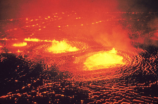
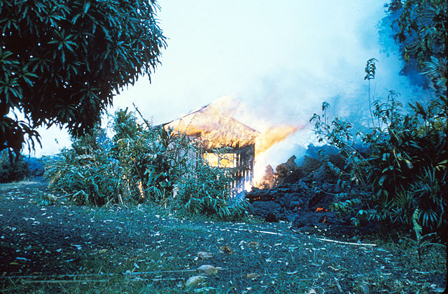
In the years following World War II, Kīlauea presented several major eruptions. The 1952 eruption lasted 136 days. This picture from the 1954 eruption helps me imagine what William Ellis saw more clearly than his 1823 drawing.
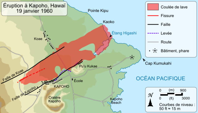
We prefer to admire Pele’s magnificence from a distance, but sometimes the goddess comes up close and personal. The 1960 eruption buried Kapoho village.
Current activity began on Jan. 3, 1983 and shows no signs of stopping, making it one of the longest volcanic eruptions in the world. Kīlauea has two major rift zones from the caldera. The East Rift Zone, where the lava has been flowing, includes several communities. The 1986 lava flow destroyed and partly buried the communities of Kalapana, the Kalapana Gardens and Royal Gardens subdivisions, and Kaimū.
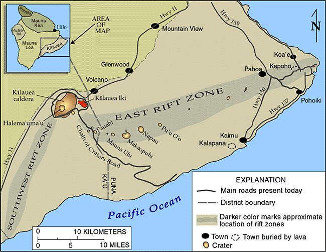
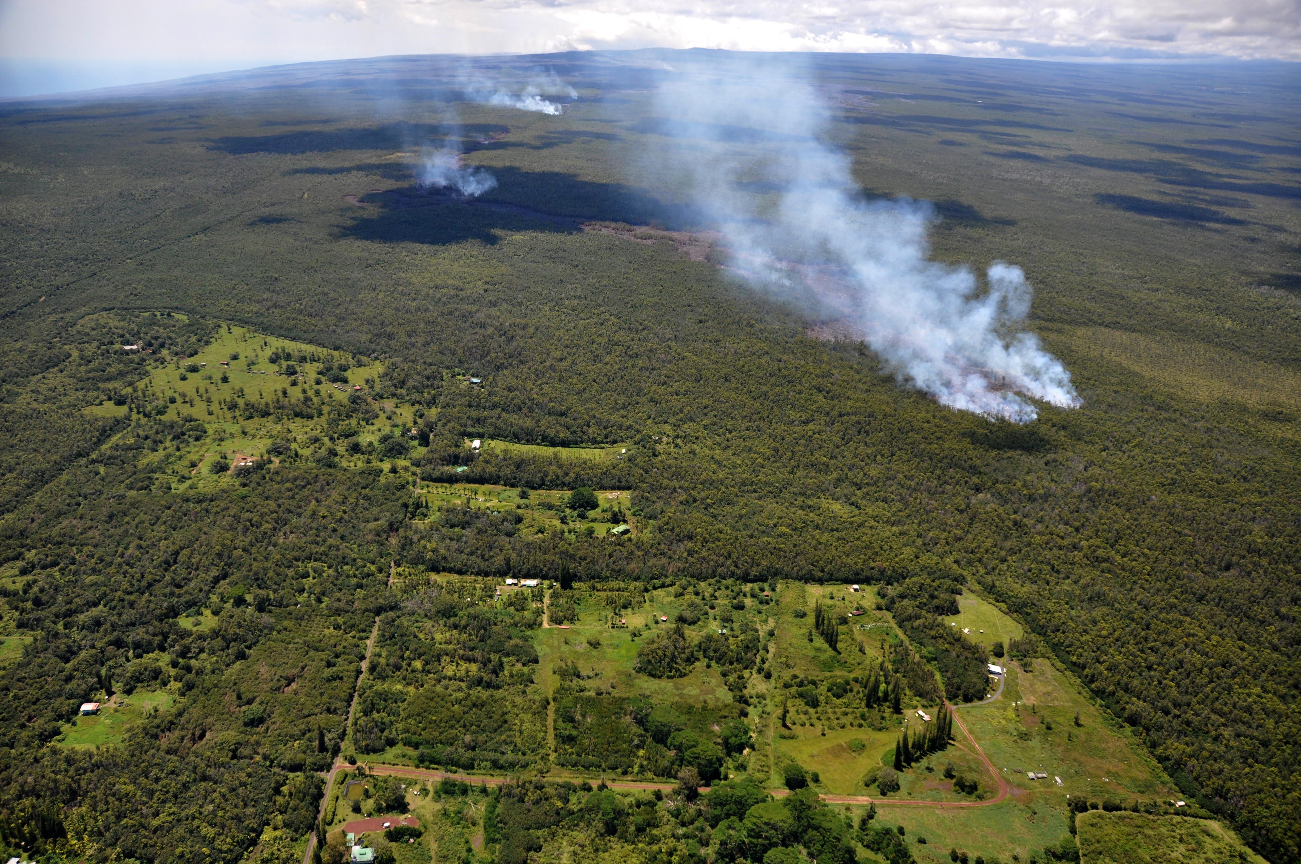
On June 27th Pele inaugurated a lava flow that threatens the communities of Pāhoa and Ka`ohe Homesteads. The lava front is moving through the Wao Kele o Puna forest reserve at a rate of about 270 yards daily, with the actual length of the flow just over ten miles Civil Defense hasn’t yet ordered residents in threatened areas to evacuate, but there’s an expectation that the lava will reach some or all of Pāhoa town and quite possibly cross Highway 130, cutting off Lower Puna. The County is clearing Railroad Avenue, an overgrown former rail bed, and Government Beach Road to provide alternate routes between Hawaiian Paradise Park and Hawaiian Beaches. Meanwhile, Pele continues to create as she destroys.
As observed on Hawai`i Volcanoes National Park website: “Each eruption is a reminder of the power of natural processes to change the air we breath, the ground we walk on, and the sea that surrounds this volcanic island we call home.”
People in Pāhoa have a more immediate concern – whether or how much of their town will survive. As Catarina Zaragoza remarked to Hawaii Tribune Herald Reporter Tom Callis, Pāhoa is “a landmark and it’s own place. . . . There would be no getting it back again, ever.”
Acknowledgements:
Featured Image: Goddess Pele holding Hi`iaka’s egg in her right hand and an `ō`ō (digging stick) in her left hand. Painting by Arthur Johnsen. Image authorized for Fair Use by Hawai`i Volcanoes National Park. Wikimedia Commons.
Tom Callis. “Pahoa Within Pele’s Grasp.” Hawaii Tribune Herald, Sept. 13, 2014, p. 1.
William Ellis. Journal of William Ellis.
Hawai`i Volcanoes National Park Website.
Hawai`i Volcano Observatory Website.

Sandra Wagner-Wright holds the doctoral degree in history and taught women’s and global history at the University of Hawai`i. Sandra travels for her research, most recently to Salem, Massachusetts, the setting of her new Salem Stories series. She also enjoys traveling for new experiences. Recent trips include Antarctica and a river cruise on the Rhine from Amsterdam to Basel.
Sandra particularly likes writing about strong women who make a difference. She lives in Hilo, Hawai`i with her family and writes a blog relating to history, travel, and the idiosyncrasies of life.
Thank-you!
ox
As always….very informative. However, I didn’t see any information on the 1946 eruption. I was here in Hilo and witnessed much of the disaster goings-on. It was a tragedy for me, my mother and my son whose Godfather was killed in Laupahoehoe helping to save teachers, etc. (Did I miss the article?) Mahalo! xoxoxoxdk
Well researched and written, but then, that is one of your hallmarks!
To Dora Kraul…the April 1, 1946 event you refer to was not a volcanic eruption but a tsunami.
Mahalo, Sonia. There were a number of significant 20th century eruptions from Kīlauea. There were major eruptions in 1918-1919 and 1924. The lava fountains in 1952 lasted 136 days. There were no major eruptions in 1946 — the tsunami was enough natural “wrath” for one year.